Historic Map Collection
The following is an exclusive collection of seven reproduction
maps of New France and British North America in the 18th Century.
Informative and
visually striking, these maps are both an excellent resource for the scholar as well as
being perfect for the wall of anyone's home or office.
A limited number has printed
and once they are gone we will not be reproducing them again.
Don't miss this
opportunity.
We offering these beautiful prints for only
24.50US
(29.50CAN) (plus
4.50US (5 CAN) shipping).
If you wish to purchase
entire collection of seven maps, the series is available to you for the
low price of
95 US (99.50CAN).
(Museum and other gift shops
please inquire about our wholesale prices.)
Shipping Costs:
1 to 3 prints ...........
6.50US (6.50CAN)
4 to 16 prints.......... .9.50US (9.50CAN)
Limited Quantities
(Click on the images to enlarge)
IMAGE
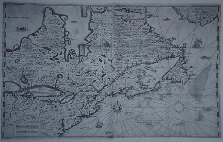
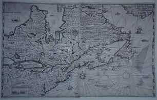
MAP005 "Carte de la nouvelle
france..."
par Samuel de Champlain, Paris, 1632.
Samuel de Champlain's final map
stands out among the early maps of Canada as a magnificent compilation of geographic
information about New France as it was known in 1629, the year the French were expelled
from the St. Lawrence Rvier Valley by British Privateers.
If you
wish to see this map in miniature form, it is on the back of the Canadian
$100 Dollar Bill.
Overall Print Size with White Border and Title: 16" X 20" ( 40.6
cm X 50.8cm)
Size of Image: 11" X 17 7/8" (28 cm X 45 cm).
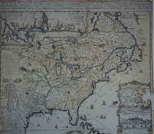
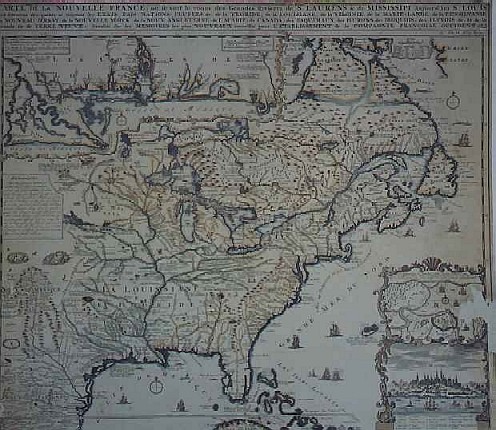
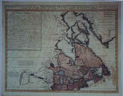
IMAGE
MAP001 "CARTE DE LA NOUVELLE FRANCE ou se
voit le cours des Grandes Rivieres de S.LAURENS & de MISSISSIPPI Aujour d'hui S.LOUIS
Chatelain, 1719
This map was copied and reduced
by Chatelain from a larger map by Nicolas de Fer.
The smaller map made a more
effective promotional piece for the Companil Francoise Occident which was responsible for
the Louisiana Territory.
The two inserts of this map show (1) the urban layout of
Quebec City and (2) forts and coast line at the mouth of the Mississippi. It is really a
fascinating map of North America.
Overall Print Size with White Border and Title: 16" X 20" ( 40.6
cm X 50.8cm)
Size of Image: 16 1/2" X 14 1/8" (42 cm X 36 cm).
Black and White image - Map for sale is in
Colour
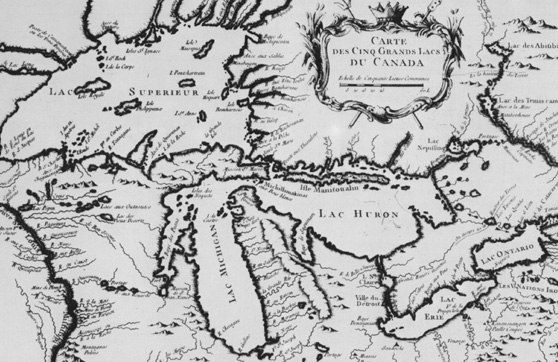
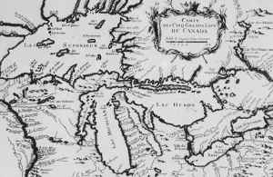
MAP002
"Carte Des Cinq Grands
Lac du Canada" par Jacques Nicholas Bellin, Paris, 1764
(Map of the Five
Canadian Great Lakes)
By the mid-18th century Bellin
had become a leading geographical engineer of Paris and Versailles.
First official
hydrographic engineer attached to the French office of marine maps and plans, he produced
in 1764 a maritime atlas containing this map showing the topography, forts, portages and
the Mission Ste. Marie in the Great Lakes area.
While published in 1764, the details
place its execution to the early 1750s.
Overall Print Size with White Border and Title: 16" X 20" ( 40.6
cm X 50.8cm)
Size of Image: 11 1/2" X 17 1/4" (29 cm X 44 cm).
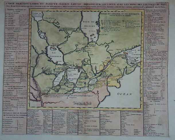
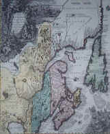
IMAGE
MAP003 "Carte Particuliere du Fleuve Saint
Louis Dressee sur les Lieux..." par H.A. Chatelain, Paris, 1719.
Despite its anachronisms, this
"natural history" map contains in the lists around its margin much useful
historical information. It is based on less accurate cartographical information than the
other 1719 map from the same atlas, and uses the old French name for the Mississippi (the
Saint Louis), in the title , but not on the map.
The area shown is mainly Canada,
however, and it is of interest from the points of view of the fur trade, natural history,
native peoples, and French language.
Overall Print Size with White Border and Title: 16" X 20" ( 40.6
cm X 50.8cm)
Size of Image: 15 3/4" X 12 3/4" (40 cm X 32.5 cm).
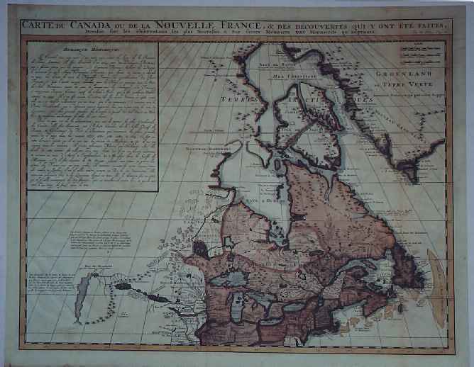
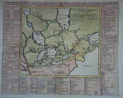
IMAGE
MAP004 "Carte du Canada ou de la Nouvelle
France...." par H.A. Chatelain, Paris, 1719.
With a few minor changes, this
map is based almost exactly on Guillaume De L'Isle's famous map of 1703 of approximately
the same title.
The major difference is that, in place of the elaborate cartouche
and title block on the De L'Isle map, this one substitutes "Remarque
Historique", an account of early French exploration in North America.
Overall Print Size with White Border and Title: 16" X 20" ( 40.6
cm X 50.8cm)
Size of Image: 13 3/4" X 17 1/4" (35 cm X 44 cm).
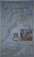
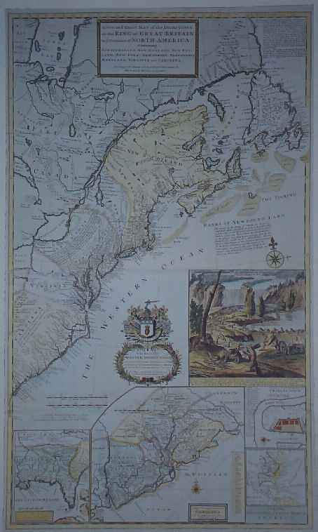
IMAGE
MAP006 " A New and Exact Map of the
Dominions of the King of Great Britain on ye Continent of North America" by Herman
Moll, London, 1715, revised 1732 or later.
This map, aptly called the
"Beaver Map" popularized Canada's national emblem with the "View of ye
Industry of ye Beavers of Canada in making Dams".
All the American
colonies are detailed on this map
including an insert of "improved part"
of Carolina
along with the layout of Charlestown.
Overall Print Size with White Border and Title: 16" X 20" ( 40.6
cm X 50.8cm)
Size of Image: 18" X 10 3/4" (46 cm X 27 cm).
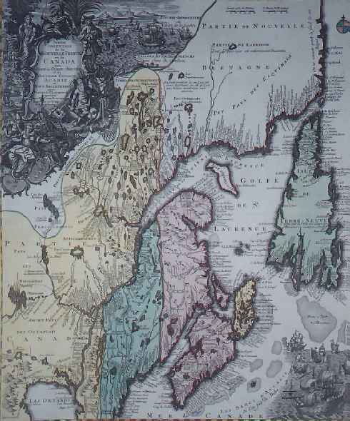
IMAGE
MAP007 "Partie Orientale de la Nouvelle
France ou du Canada", Tobias Conrad Lotter, 1762.
This map is typical of the
German school of thought towards map making with its ornate artwork and engraving.
It is particularly interesting to the navigator because of the detailing of the flow of
the rivers and the surprising accuracy of the inlets, etc. considering distorted
interpretation of the land masses. Overall Print Size with White Border and Title:
16" X 20" ( 40.6 cm X 50.8cm)
Size of Image: 15" X 17 3/4"
(38 cm X 45 cm).